Cycling · Black Rock Desert, Nevada, USA · recorded with NomadTracks
Riding Black Rock City: the GPS trace of a city that doesn't exist
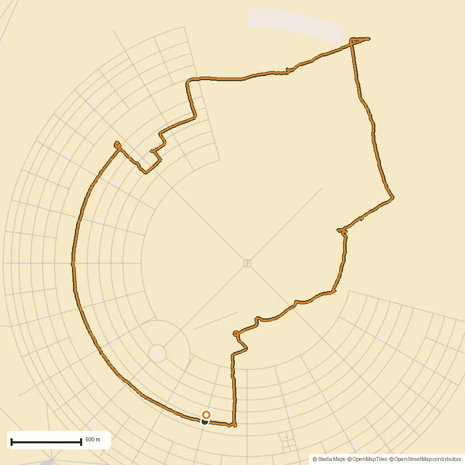
Once a year, a circular city for 70,000 people appears on a Nevada lakebed — and a week later it's gone without a trace. Except this one: a 9.7 km bike ride through Black Rock City, recorded with NomadTracks. The map below shows the ride arcing along the city's ringed streets and cutting across the open playa — a trace of a city that will have vanished by the time you read this.
About this data: this track and its photos were personally shared with us as samples by a NomadTracks user. NomadTracks never uploads, collects or shares your tracks or photos — your recordings stay on your devices and in your own cloud.
Download GPX Coordinates, elevation and relative times — recording dates are normalized out, photos not included.

A track of a temporary place
Black Rock City has addresses — the clock-face-and-ring system — but no permanence; even OpenStreetMap's faint outline of the grid describes a city that exists for one week a year. The recorded track is personal cartography that survives the city: every arc a ringed street, every cut a crossing of the open playa.
Dust-proof recording
The playa eats electronics; the phone stayed sealed in a bag in the basket, recording blind all day. Live Activities meant a glance at the lock screen — through the ziplock — was enough to check the day's distance. The bike, as always out there, was the only sane way to move.
About the place: Black Rock Desert, Nevada, USA
Black Rock City is erected each late August on the Black Rock Desert playa, about 150 km north of Reno, Nevada, and dismantled to nothing days later under the event's leave-no-trace ethos. Bikes are the city's primary transport: distances are deceptive on the 10-square-kilometer site, dust storms erase sightlines in seconds, and a GPS breadcrumb back to your camp is more than a gimmick.
Get NomadTracks free on the App Store
More track stories
- Overlanding Namibia: 4,250 km from the Kalahari to the Kunene
- Mount Whitney in two days: 24 km to the roof of the Lower 48
- Grant Park, the Bean & the Museum Campus: a 10.5 km Chicago run
- A morning run through downtown Chicago: 9.7 km past Navy Pier and the lakefront
- Running Lincoln's Springfield: 8.8 km through the Illinois capital
- Camps Bay to Table Mountain: the steep way up Cape Town's icon
- Dürrensee to the Drei Zinnen: a Dolomites classic
- Maurer Wald loop: a 9.7 km trail run on the edge of Vienna
- Camping Šobec and the birth of the Sava: a 7 km morning run
- Sailing the Šibenik archipelago: 69 nautical-style kilometers under sail
- Canoeing Caddo Lake: 9 km through a flooded cypress forest
- Mount Shasta mountain-bike loop: 28.6 km of volcano singletrack
- Lofoten lake hike: 9.6 km through Norway's green wilderness
- Cinder Cone, Lassen Volcanic NP: a 6 km climb up a perfect volcano
- Drakensberg amphitheatre: 13 km to the top of Tugela Falls
- The Olive Trail, Namib-Naukluft: 10.9 km through a desert canyon
- Mount St. Helens: 16 km through the blast zone to the viewpoints
- Double O Arch via Devils Garden: 12 km through Arches' fin country
- The everyday loop: 12 km of redwoods and fog above Redwood City
- Lake Tahoe rim ride: 28 km of singletrack above the blue
- Dewey Point in winter: 12 km on snowshoes to Yosemite's quiet rim
- Pinnacles High Peaks loop: 12 km among the condor spires
- Golden Canyon to Zabriskie badlands: 6 km below sea level
- Hoh Rain Forest: a 4 km walk through the moss cathedral
- Oahu waterfall trail: 5 km of mud, roots and jungle
- Riding to Lake Helen: 17 km up a closed park road through the snow
- Phillips Cave: a 6.5 km walk to Namibia's White Elephant rock art
- Koiimasis: 9 km through the granite of the Tiras Mountains
- Cathedral Gorge: a short ride through Nevada's clay cathedral
- Peekaboo Loop, Bryce Canyon: 15 km among the hoodoos