Running · Chicago, Illinois, USA · recorded with NomadTracks
A morning run through downtown Chicago: 9.7 km past Navy Pier and the lakefront
A city at its best hour: this is a 9.7-kilometer morning run through downtown Chicago, recorded on a clear late-June morning when the Magnificent Mile is still quiet and the lakefront is just waking up.
Just over an hour, almost completely flat, the loop strings together the landmarks of the Near North lakeshore — the Mag Mile, Navy Pier and its Centennial Wheel, the flag-lined promenade over the harbour, Ohio Street Beach and the John Hancock above the Lakefront Trail — and comes back to where it started.
About this data: this track and its photos were personally shared with us as samples by a NomadTracks user. NomadTracks never uploads, collects or shares your tracks or photos — your recordings stay on your devices and in your own cloud.
Download GPX Coordinates, elevation and relative times — recording dates are normalized out, photos not included.

A flat, fast lap of the lakeshore
Downtown Chicago is a runner's city: a continuous Lakefront Trail, wide promenades and a skyline that never lets up. This loop runs east from the Magnificent Mile out to the tip of Navy Pier, then back along the water past the beach and under the John Hancock Center. Eight metres of elevation gain over nearly ten kilometres — downtown, the only climbs are the river bridges.
Landmarks, one after another
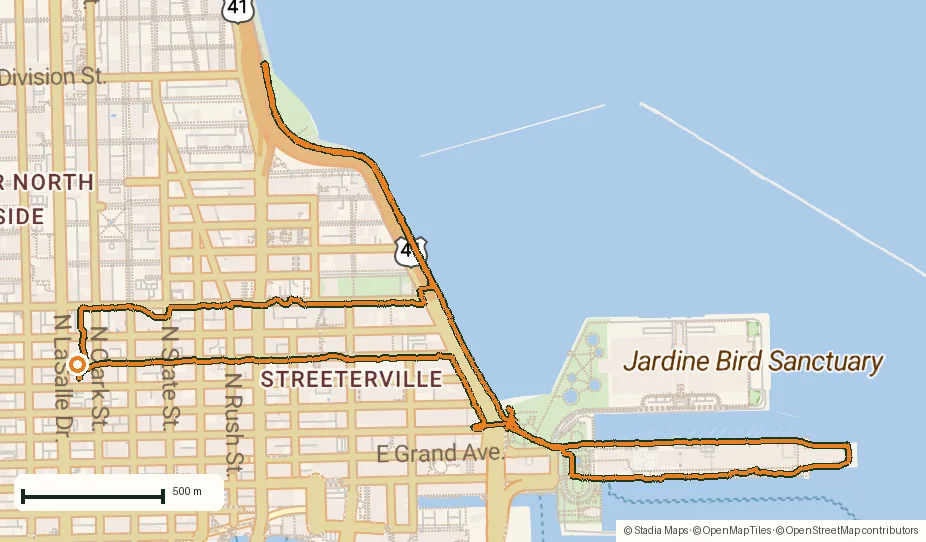
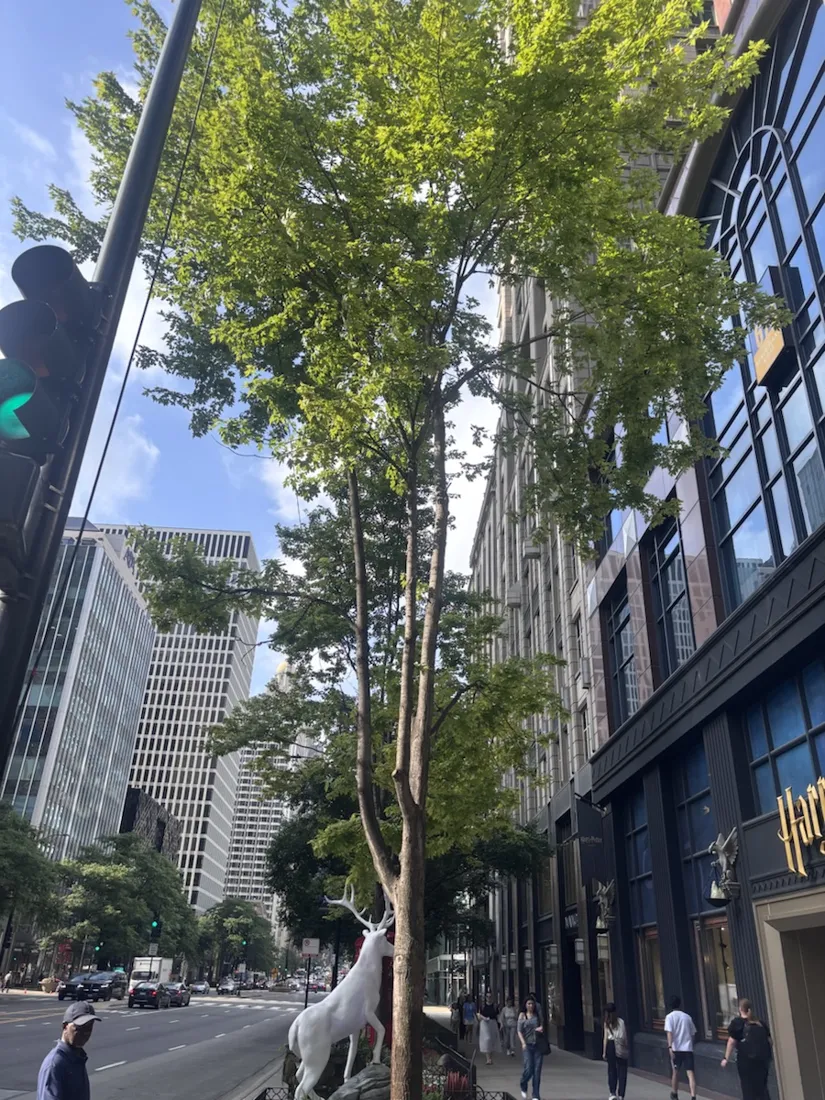
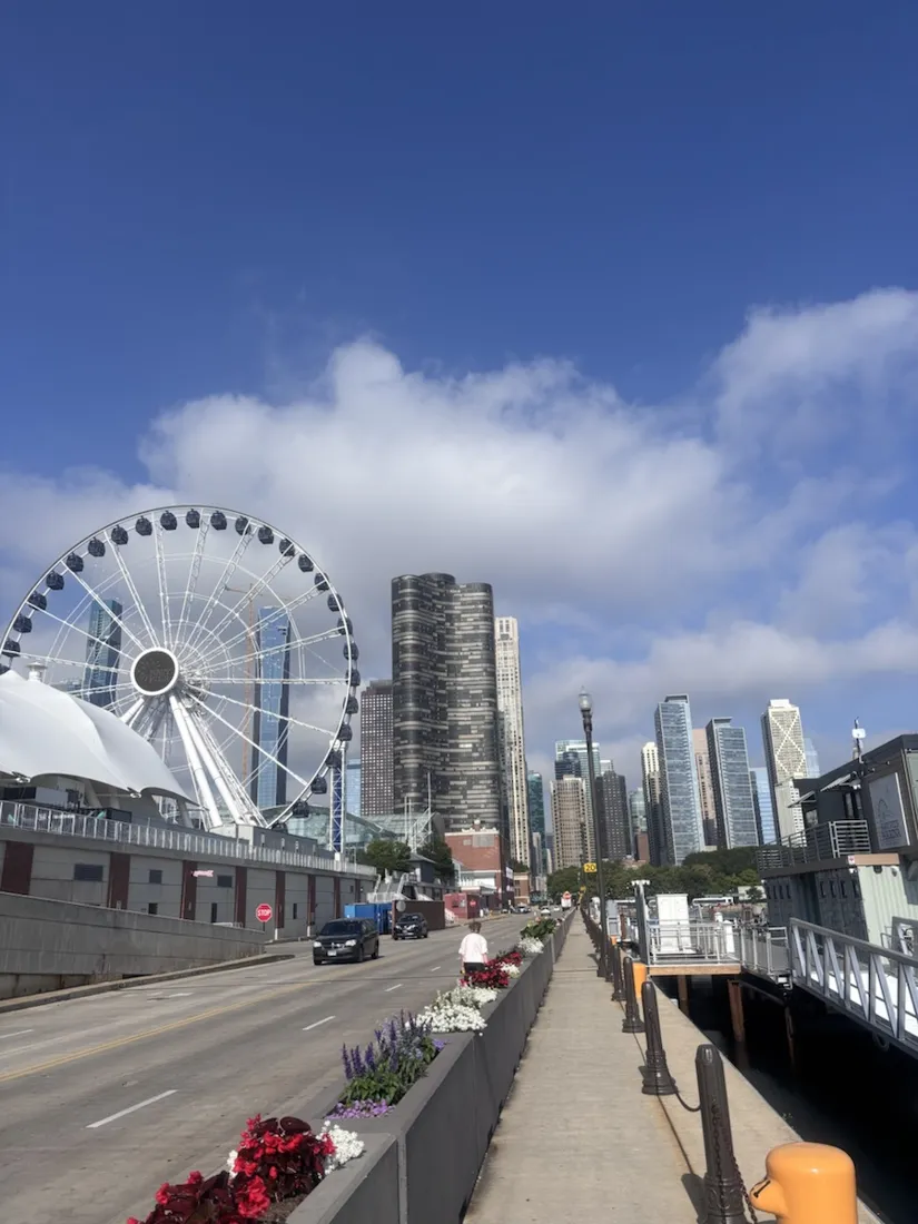
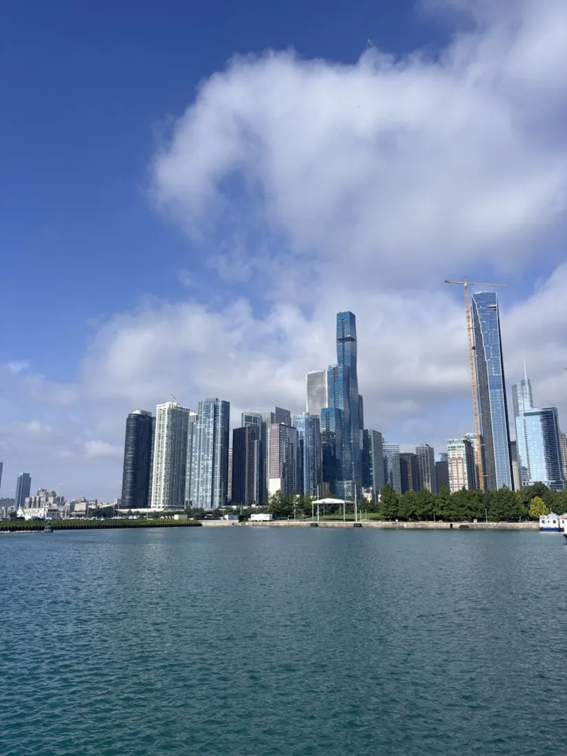
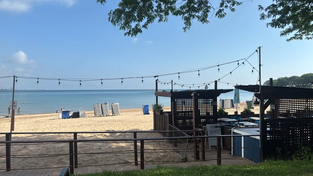
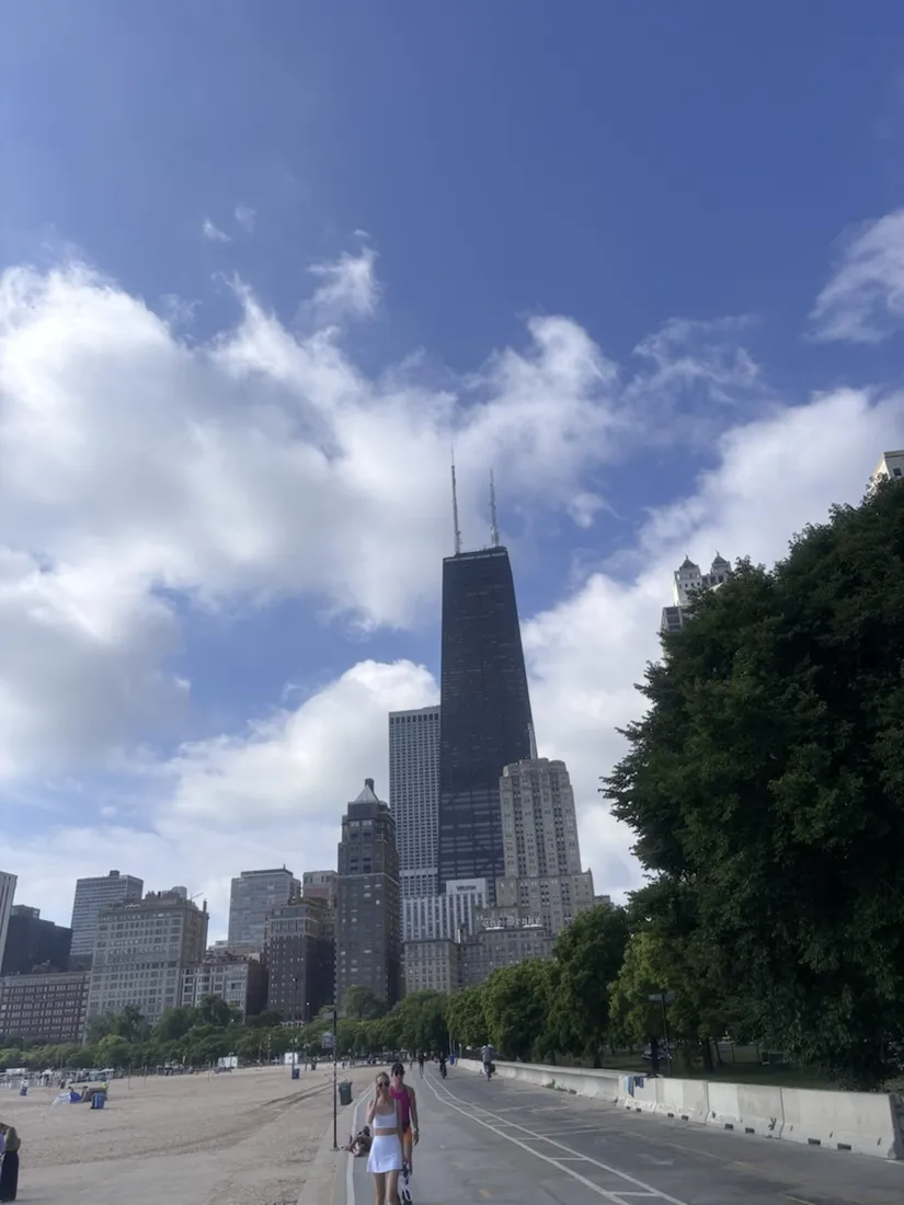
The recorded photos drop onto the map exactly where they were taken, and in Chicago that means a landmark every few minutes. The loop opens on the Magnificent Mile — North Michigan Avenue's mile of department stores, hotels and the old Water Tower — then cuts east to Navy Pier, half a mile of pier reaching into the lake under the 196-foot Centennial Wheel. Out at the pier's tip, a flag-lined promenade looks across the water to the red Chicago Harbor Lighthouse on its breakwater. The way back hugs the lakefront: the full downtown skyline rises across the harbour with the tiered St. Regis Tower at its centre; Ohio Street Beach appears with Caffè Oliva and its loungers right on the sand; and the black, tapered John Hancock Center (875 North Michigan) stands over the beach as the Lakefront Trail carries you home. It's a sightseeing run as much as a workout.
Why record a city run
A flat road loop isn't about navigation stakes or elevation drama — but the line still tells the story: the exact route, the real pace, and a GPX that anyone could follow to run the Chicago lakefront themselves. Every chart and the map came straight out of the app.
About the place: Chicago, Illinois, USA
Chicago sits on the south-western shore of Lake Michigan, and its Near North lakefront is among the most runnable stretches of any U.S. city. The roughly 18-mile Lakefront Trail follows the water almost uninterrupted; Navy Pier, with its 196-foot Centennial Wheel, juts about half a mile into the lake; and the Magnificent Mile carries North Michigan Avenue past the John Hancock Center (875 North Michigan) and the historic Water Tower. The terrain is famously flat — downtown, the only inclines are the bascule bridges over the Chicago River.
Get NomadTracks free on the App Store
More track stories
- Overlanding Namibia: 4,250 km from the Kalahari to the Kunene
- Mount Whitney in two days: 24 km to the roof of the Lower 48
- Running Lincoln's Springfield: 8.8 km through the Illinois capital
- Camps Bay to Table Mountain: the steep way up Cape Town's icon
- Dürrensee to the Drei Zinnen: a Dolomites classic
- Maurer Wald loop: a 9.7 km trail run on the edge of Vienna
- Sailing the Šibenik archipelago: 69 nautical-style kilometers under sail
- Canoeing Caddo Lake: 9 km through a flooded cypress forest
- Mount Shasta mountain-bike loop: 28.6 km of volcano singletrack
- Lofoten lake hike: 9.6 km through Norway's green wilderness
- Cinder Cone, Lassen Volcanic NP: a 6 km climb up a perfect volcano
- Drakensberg amphitheatre: 13 km to the top of Tugela Falls
- The Olive Trail, Namib-Naukluft: 10.9 km through a desert canyon
- Mount St. Helens: 16 km through the blast zone to the viewpoints
- Double O Arch via Devils Garden: 12 km through Arches' fin country
- The everyday loop: 12 km of redwoods and fog above Redwood City
- Lake Tahoe rim ride: 28 km of singletrack above the blue
- Dewey Point in winter: 12 km on snowshoes to Yosemite's quiet rim
- Pinnacles High Peaks loop: 12 km among the condor spires
- Golden Canyon to Zabriskie badlands: 6 km below sea level
- Hoh Rain Forest: a 4 km walk through the moss cathedral
- Oahu waterfall trail: 5 km of mud, roots and jungle
- Riding to Lake Helen: 17 km up a closed park road through the snow
- Phillips Cave: a 6.5 km walk to Namibia's White Elephant rock art
- Koiimasis: 9 km through the granite of the Tiras Mountains
- Cathedral Gorge: a short ride through Nevada's clay cathedral
- Riding Black Rock City: the GPS trace of a city that doesn't exist
- Peekaboo Loop, Bryce Canyon: 15 km among the hoodoos