Hiking · Drakensberg, South Africa · recorded with NomadTracks
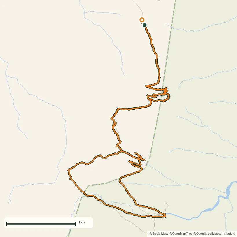
Drakensberg amphitheatre: 13 km to the top of Tugela Falls
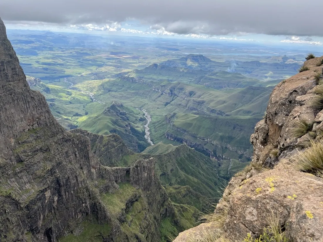
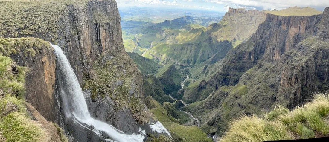
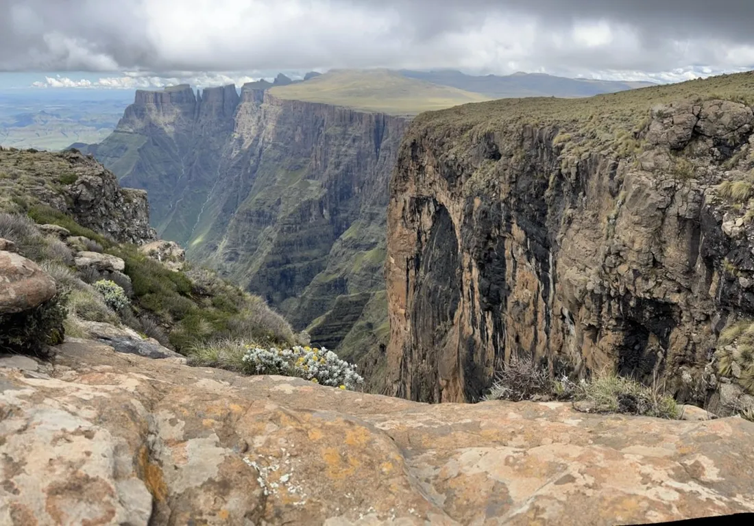
The Drakensberg amphitheatre is a five-kilometer wall of basalt, and this 13.1 km route climbs to its rim — where the Tugela river simply steps off the edge and falls the better part of a kilometer. About 850 m of gain, big exposure, bigger views.
About this data: this track and its photos were personally shared with us as samples by a NomadTracks user. NomadTracks never uploads, collects or shares your tracks or photos — your recordings stay on your devices and in your own cloud.
Download GPX Coordinates, elevation and relative times — recording dates are normalized out, photos not included.

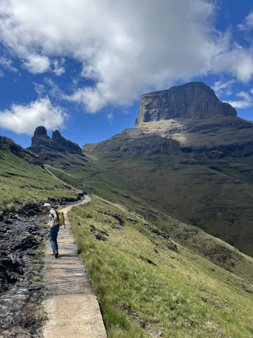
Up the escarpment
From the Sentinel side the route works up ramps and gullies to the plateau — the famous chain ladders are the crux, short but airy. On top, the world flattens absurdly: a grassy roof at 3,000 m with the falls' lip a casual stroll away.
Weather windows, recorded
Berg weather builds fast after noon. The recorded timeline is the honest debrief: how long the ascent really took and how much margin was left when the first clouds boiled up the wall — exactly the data that plans the next attempt better.
Tugela Falls coordinates (latitude and longitude)
Tugela Falls coordinates: the lip of the falls is at latitude −28.7523, longitude 28.8946 (decimal degrees) — or 28°45′08″ S, 28°53′41″ E in DMS — on the amphitheatre rim at about 2,970 m. This recorded track ends within meters of that point, so the GPX download above takes you exactly there. The approach starts from the Sentinel Peak car park above Witsieshoek (recorded start point: −28.7278, 28.8913), climbs the ramps to the chain ladders, and crosses the plateau to the falls. Tugela (Thukela) Falls drops roughly 948 m in five tiers — a 2016 survey measured 983 m, which would make it the world's tallest. Enter the coordinates into NomadTracks as a POI and it shows live distance to the lip the whole way up.
About the place: Drakensberg, South Africa
The Drakensberg amphitheatre in Royal Natal National Park, South Africa, is a five-kilometer basalt wall on the Lesotho border, and Tugela Falls — among the tallest waterfalls on earth at 948 m — pours straight off its rim. The hike starts at the Sentinel car park above Phuthaditjhaba; the chain-ladder section is short but airy, and mountain weather builds fast after midday year-round.
Get NomadTracks free on the App Store
More track stories
- Overlanding Namibia: 4,250 km from the Kalahari to the Kunene
- Mount Whitney in two days: 24 km to the roof of the Lower 48
- Grant Park, the Bean & the Museum Campus: a 10.5 km Chicago run
- A morning run through downtown Chicago: 9.7 km past Navy Pier and the lakefront
- Running Lincoln's Springfield: 8.8 km through the Illinois capital
- Camps Bay to Table Mountain: the steep way up Cape Town's icon
- Dürrensee to the Drei Zinnen: a Dolomites classic
- Maurer Wald loop: a 9.7 km trail run on the edge of Vienna
- Camping Šobec and the birth of the Sava: a 7 km morning run
- The Slow Trail around the Pressegger See: a 5.7 km reed-belt loop
- Vorderberg to the Dellacher Alm: a wild 13 km off-trail climb in the Carnic Alps
- Sailing the Šibenik archipelago: 69 nautical-style kilometers under sail
- Canoeing Caddo Lake: 9 km through a flooded cypress forest
- Mount Shasta mountain-bike loop: 28.6 km of volcano singletrack
- Lofoten lake hike: 9.6 km through Norway's green wilderness
- Cinder Cone, Lassen Volcanic NP: a 6 km climb up a perfect volcano
- The Olive Trail, Namib-Naukluft: 10.9 km through a desert canyon
- Mount St. Helens: 16 km through the blast zone to the viewpoints
- Double O Arch via Devils Garden: 12 km through Arches' fin country
- The everyday loop: 12 km of redwoods and fog above Redwood City
- Lake Tahoe rim ride: 28 km of singletrack above the blue
- Dewey Point in winter: 12 km on snowshoes to Yosemite's quiet rim
- Pinnacles High Peaks loop: 12 km among the condor spires
- Golden Canyon to Zabriskie badlands: 6 km below sea level
- Hoh Rain Forest: a 4 km walk through the moss cathedral
- Oahu waterfall trail: 5 km of mud, roots and jungle
- Riding to Lake Helen: 17 km up a closed park road through the snow
- Phillips Cave: a 6.5 km walk to Namibia's White Elephant rock art
- Koiimasis: 9 km through the granite of the Tiras Mountains
- Cathedral Gorge: a short ride through Nevada's clay cathedral
- Riding Black Rock City: the GPS trace of a city that doesn't exist
- Peekaboo Loop, Bryce Canyon: 15 km among the hoodoos