Sailing · Šibenik, Croatia · recorded with NomadTracks
Sailing the Šibenik archipelago: 69 nautical-style kilometers under sail
Sixty-nine kilometers of Adriatic between the Kornati edge and the Šibenik channel: this track is one long day under sail, recorded from a phone in the cockpit with nautical units switched on.
On the water the track itself becomes the logbook — every tack and every lazy lunch-bay stop is in the line.
About this data: this track and its photos were personally shared with us as samples by a NomadTracks user. NomadTracks never uploads, collects or shares your tracks or photos — your recordings stay on your devices and in your own cloud.
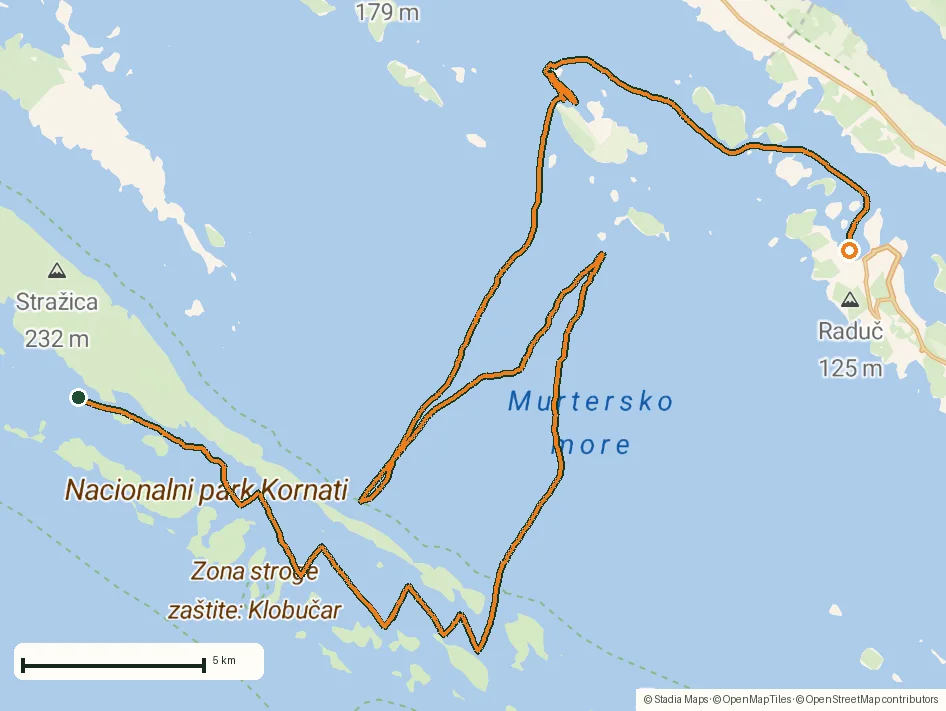
Download GPX Coordinates, elevation and relative times — recording dates are normalized out, photos not included.

Tracks as a sailing logbook
Speed-over-ground is recorded continuously, so the speed chart doubles as a trim diary: you can see exactly when the afternoon Maestral filled in. Marinas, anchorages and konobas worth returning to are dropped as POIs with photos and notes.
Nautical units, offline charts
NomadTracks speaks knots and nautical miles when you want it to. And because custom maps work offline, a scanned pilot-book chartlet of the archipelago can ride along as a georeferenced overlay — handy redundancy when the chartplotter belongs to the charter boat, not to you.
About the place: Šibenik, Croatia
The Šibenik archipelago on Croatia's Dalmatian coast borders the Kornati National Park — a labyrinth of more than a hundred bare limestone islands that is one of the Mediterranean's classic charter sailing grounds. The season runs May to October; mornings are typically calm with the Maestral sea breeze filling in reliably after noon, and protected coves with mooring buoys or small konoba restaurants are rarely more than an hour's sail apart.
Get NomadTracks free on the App Store
More track stories
- Overlanding Namibia: 4,250 km from the Kalahari to the Kunene
- Mount Whitney in two days: 24 km to the roof of the Lower 48
- Grant Park, the Bean & the Museum Campus: a 10.5 km Chicago run
- A morning run through downtown Chicago: 9.7 km past Navy Pier and the lakefront
- Running Lincoln's Springfield: 8.8 km through the Illinois capital
- Camps Bay to Table Mountain: the steep way up Cape Town's icon
- Dürrensee to the Drei Zinnen: a Dolomites classic
- Maurer Wald loop: a 9.7 km trail run on the edge of Vienna
- Camping Šobec and the birth of the Sava: a 7 km morning run
- Canoeing Caddo Lake: 9 km through a flooded cypress forest
- Mount Shasta mountain-bike loop: 28.6 km of volcano singletrack
- Lofoten lake hike: 9.6 km through Norway's green wilderness
- Cinder Cone, Lassen Volcanic NP: a 6 km climb up a perfect volcano
- Drakensberg amphitheatre: 13 km to the top of Tugela Falls
- The Olive Trail, Namib-Naukluft: 10.9 km through a desert canyon
- Mount St. Helens: 16 km through the blast zone to the viewpoints
- Double O Arch via Devils Garden: 12 km through Arches' fin country
- The everyday loop: 12 km of redwoods and fog above Redwood City
- Lake Tahoe rim ride: 28 km of singletrack above the blue
- Dewey Point in winter: 12 km on snowshoes to Yosemite's quiet rim
- Pinnacles High Peaks loop: 12 km among the condor spires
- Golden Canyon to Zabriskie badlands: 6 km below sea level
- Hoh Rain Forest: a 4 km walk through the moss cathedral
- Oahu waterfall trail: 5 km of mud, roots and jungle
- Riding to Lake Helen: 17 km up a closed park road through the snow
- Phillips Cave: a 6.5 km walk to Namibia's White Elephant rock art
- Koiimasis: 9 km through the granite of the Tiras Mountains
- Cathedral Gorge: a short ride through Nevada's clay cathedral
- Riding Black Rock City: the GPS trace of a city that doesn't exist
- Peekaboo Loop, Bryce Canyon: 15 km among the hoodoos